Communications between Angola and East Central Africa before c. 1700
Related Material:
The Issue
It is well known that many of the history of Angola has been profoundly affected by the introduction of many innovations from East Central Africa. [1] These include cereal crops and the techniques to grow them, the herding of sheep and bovid cattle, and later on a series of crops which ultimately stemmed from tropical Asia as well as some other less known features. [2] Angolan Bantu languages have also been strongly influenced by their East Central African counterparts especially in the reduction of a seven vowel to a five vowel system, by the spirantisation of consonants which accompanied it, but also by the adoption of some grammatical features. [3] All this borrowing, however, was not just one way. East Central Africa did also borrow some features from Angola as well.
While no one doubts that such diffusions occurred, no one seems to have given much thought about how and when all of this happened. As to the when, some of the introductions are very old. That is the case for the adoption of sheep or bovid cattle which are dated directly by their remains respectively to the beginning and the middle of the first millenium. Others however such as for instance the diffusion from west to east of American crops like maize, manioc, or tobacco date to the seventeenth and eighteenth centuries. We are therefore dealing with a traffic between west and east which lasted for the best part of the last two millenia. [4]
As to how, its seems to have been tacitly understood that most and perhaps all of these items diffused by being passed on between inhabitants of adjacent villages as part of their ordinary relationships with each other whether these concerned marriage alliances, the exchange of goods and services, co-operative activities, the sharing of experts, or even the resolution of intercommunal disputes. [5] This assertion certainly holds true for any area in which people share a common language since they cannot continue to do so without sufficiently frequent intercommunication. Whether this holds true beyond a single language area is less certain. If it does, innovations should have slowly diffused along a broad front, rather like water running over a floor, all along the borders between east and west between the rainforests in the north and the Okavango Delta swamps in the south.
Yet empirical evidence shows that this did not happen. An examination of traceable individual borrowing indicates that nearly all the transfers occurred either around the southern end of the common border, that is around the Okavango Delta swamps (parallels 18º-20º S) or around the northern end between the parallels 5º-8º S. It looks as if a barrier prevented interchange everywhere else, although this barrier was dented but not wholly broached west of the headwaters of the Zambezi River (between parallel 11º-14º S). Some of the evidence at hand is archaeological, some is biological (plants and animals), but most of it lies embedded in the vocabularies of different languages or different blocks of closely related languages all across the area. A comparison of words permits us to trace transfers from language to language and in favorable cases allows us to discover fairly precise paths by which they passed from language to language between east and west. In particular one can use words for items whose ultimate origin, age, and direction of borrowing are known – usually but not only in the case of plants and animals – as indicators which reveal where the channels of communication ran at the time of their diffusion. For example words for chicken, a bird of Asiatic origin, shows us that one word for it (nsúswá 9/10, nsúsú 9/10) crossed from east to west by the southern passage around the barrier probably between c. 700-900 AD and then moved northwards across the whole of Angola and the southern Congo. Yet at the same time another word (kasumbi 12/13) moved directly from central Zambia into eastern Angola via the headwaters of the Zambezi River , but did not affect any region west of the Okavango and Kwango Rivers. [6] In addition to these cases there are the distributions of a large number of other words which refer to items of known origin which help us to determine what channels of communication did exist at one time even if they cannot be well dated. [7]
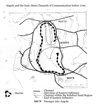
The Kalahari Sands as a Barrier
All these distributions confirm that there really was a barrier preventing a direct transfer between east and west. The same barrier also clearly appears on linguistic maps which show the degree of similarity in the basic vocabulary of adjacent languages, and therefore measure the degree of communication between them. [8] Such data show that the barrier consists in the expanse of infertile Kalahari Sands and that it stretched all across eastern Angola into adjacent parts of Congo, between the Okavango River, the planalto and the Kwango River to the west and the upper Zambezi floodplain, the eastern reaches of the headwaters of the Zambezi River, and the middle Kasai River to the east. In these lands people can practically only cultivate on the "red" soils of the river valleys where these have pierced the mantle of overlying sands. Hence settlements are strung in lines along these valleys and so are the vicinages which were the fundamental territorial units of their societies. The orientation of the rivers dictated the settlement pattern.
Furthermore the sands quickly absorb any standing surface water with the result that thirst is often a problem for travelers, especially in the south where rainfall is much lower and the rainy season much shorter. Those reasons explain why southeastern Angola south of the middle Cuando River was almost completely inhabited by nomadic foragers and, except in part for the Cuando and Cuilo Valleys, shunned by sedentary farmers. This created nearly an absolute barrier between the Cuando and the Okavango Rivers since there was no chain of sedentary villages from east to west. Indeed during their crossing from the Okavango to the Cuando Rivers from west to east Capello and Ivens found out that the lack of water added to the lack of villages constituted a nearly insurmountable barrier. [9]
North of the Zambezi floodplain the river begins to receive a fan of tributaries which stem from the northwest such as the Lungue-bungo River and then further upstream others which come from the west such as the Lwena River. The upper Kasai River also flows from west to east until it suddenly turns north near Dilolo. The settlements there were primarily oriented east to west and therefore favored communication in that direction, but actually not as far west as the Cuanza and Kwango Valleys. Indeed a stretch of empty or nearly empty rough, hilly, and heavily forested land divided the headwaters of the affluents of the Zambezi and the Kasai Rivers from these river valleys. Magyar gave an impressive description of these "Olo-wihenda" forests in 1850 as a "sea of trees" separating several people who "rarely communicate with each other". [10]
Further north all the rivers and their strings of settlements run parallel to each again other in deep valleys from south to north. While a lack of standing water was usually not a major problem there, the denser forests and especially the many steep valleys one had to cross made west to east travel rather difficult. Hence this landscape also constituted a barrier to east-west movements even though communication north to south within it was fairly easy. Although all foreign observers from the late seventeenth century onwards have blamed the very existence of a barrier east of the upper Kwango River to a deliberate policy decision of the Kasanji rulers, yet a closer look at the sources indicates that it resulted to a large extent from natural conditions and very low population densities. [11]
Passages of Communication
1. The southern passage. Given the barrier to east-west communication we can now discuss the various passages which allowed for some east-west contact beginning with the one at the southern end of the barrier. There were actually two passages here, one from Zimbabwe along various pans and rivers to the southern end of the Okavango Delta swamp and then along its western edge to the lower Okavango River, and one from the middle Zambezi River, more or less along in or just north of what is now the Caprivi strip also to the lower Okavango River. From there the river was the corridor which led to southern Angola. The first evidence we have for the use of this passage stems from around 1 AD or a little earlier. Sheepherding, ceramics, and metallurgy were introduced from western Zimbabwe to northern Namibia and southern Angola by the southernmost route around a greatly enlarged Okavango Delta through an environment that was far wetter than it is today. Possibly these technologies were not just passed on from band to band but their spread may have involved some actual migration by the sheepherders. Later on some sheep at least were passed on from hand to hand further and further northwards from southern Angola to finally arrive as far northwards as the rainforests of the southern Congo.
About half a millenium later sorghum and millet and the techniques needed to cultivate them, as well as bovid cattle followed from the east by way of the southern passages into Angola and then again diffused northwards from there as far as the Cuanza Basin. These inputs have been crucial for the whole later history of all of Angola. For the new agriculture not only led to a sedentary lifestyle nearly everywhere in the area but also it fused its southern and northern parts into the single cultural area now known as West Central Africa. These innovations which came from Zambia or Zimbabwe may have been passed on along a route either north or south of the Okavango Delta, although the evidence from Tsodilo (Botswana) rather suggests a direct diffusion from the Zambezi River north of the Delta to the lower Okavango River. A century or two later, however, large herds of cattle and other goods from southeast Africa began to arrive by the southernmost route. Nqoma in the Tsodilo hills now came to be linked by what looks like a regular trading route south of the delta to Matlapaneng and then eastwards along the Botletle river to Bosutswe from where the route continued to Toutswe, to the Shashi-Limpopo confluence and ultimately to the Indian Ocean. Between c. 900 and 1100 AD, glass beads and conus shells from the East Coast reached Nqoma over the Mapungubwe region while some of its copper stemmed from Phalaborwa in Transvaal and traveled mostly along the same route. [12] One is tempted to add the domestic fowl to the list of imports by this route because the animal was actually raised at Bosutswe in the 700s. But the spread of nsúswá 9/10 for "chicken" shows that people in southern Angola and northern Namibia actually acquired the bird from people living in or near the floodplain of the upper Zambezi Valley who invented this word and that it was then passed along the Caprivi variant of the southern passage presumably in the eight or early ninth centuries. The notion of matrilineage (onkhova 9/10 in Nyaneka), which had developed among agropastoralists in southern Angola probably during the ninth century, used the same passage to move in the other direction towards the middle Zambezi River and then into most of Zambia where it gave rise to the well known mukowa 3/4 matriclan organisation.
The trading route between Tsodilo and Mapungubwe was abandoned around 1100 and so far no later evidence for the use of the northern Caprivi passage has been found before c. 1750 with the possible exception of the word mulónga 3/4 "river" carried across the Caprivi passage by fishermen no doubt. [13] Still after 1750 there has always been some communication and most likely some trade along the lower Okavango River and the Caprivi passage. [14]
2. The middle passage. The middle passage gave access to the west from the headwaters of the Zambezi River and the bend of the upper Kasai River. This region was inhabited by peoples who spoke closely related languages belonging to the Moxico group which includes Cokwe, Lwena, the Ngangela cluster, Lwimbi, and Nyemba. Within this group communication was excellent and population mobility was high. To a lesser extent this also holds for the valley of the upper Kasai River and the nearby river valleys in which the Chiumbe, the Chicapa, or even the Kwilu Rivers flowed north. Speakers of the Lunda group of languages which is the nearest linguistic relative to the Moxico languages occupied the neighboring part of the headwaters of the Zambezi River and the valleys of the Lulua and Kasai Rivers further north. Hence innovations adopted in the lands of the Zambezi River’s headwaters easily spread both upstream westwards and downstream northwards along Kasai and Lulua. Indeed some innovations also found another way northwards along the valleys between the Kwilu and the Kasai Rivers.
The spread of the earliest dated import from the east, the domestic fowl, called kasumbi 12/13 here, yields a typical pattern. The first chickens apparently came from the copperbelt area (Lamba/Lala languages) during the 800s and their care diffused among the Ndembu speakers first and then also among all the Moxico speakers but not further. [15] Plantain banana, variant dikonde 5/6, of about the same date, fits the same pattern of diffusion and came in either from the copperbelt area or from the northeast. [16] Sugarcane, musaci 3/4, perhaps a century or even two later (c. 900/1000 AD), also shows a similar pattern although it diffused from the lower Zambezi valley to southern Zambia, then to the Zambezi floodplain, and then northwards to the lands inhabited by speakers of the Lunda and Moxico language groups.
Perhaps just as early but more complex is the case of muzukulu 1/2 and variants. This word means grandchild and is of old eastern Bantu origin. It was practically universal in central and southern Zambian languages and was acquired first by Ndembu speakers from Nkoya speakers to their southeast from where it then spread to the Moxico group but not further west. Meanwhile another variant followed the eastern limit of the Kalahari Sands northwards from Ndembu to Rund speakers. Later a Cokwe variant spread northwards along the valleys between the Kwilu and Chikapa Rivers to be finally adopted by Pende speakers to the northwest. Given the ease of communication and the high mobility of all the people who lived on the Kalahari Sands from Pende speakers in the north to Mbwela speakers in the far south this last pattern of diffusion is not surprising at all. Among other traces the spread of a nearly identical terminology relating to initiations in this whole zone also shows this.
Yet another pattern is similar to the previous one mainly by its complexity. This concerns cotton. This plant and its substance, designated by another term, came from the lower Zambezi Valley to reach southern Zambia around 1200. [17] In that region it acquired a new name wandu 14, and ndandu 9/10 which then spread northwards along the Zambezi River’s floodplain to its headwaters perhaps by 1300 or so. There one term went westwards to reach the very edge of the planalto near the uppermost Okavango River. But another word continued northwards along the Kasai and the Lulua rivers into what are now the Kasai provinces, turned then around the northern edge of the Kalahari sand region westwards into Kwilu as far as the Kwango River and then southwestwards among the northern Ambundu. Elsewhere west of the Kwango River two new terms derived from words designating thread or cloth were invented to designate the plant and its product. Among the Ambundu of central Angola cotton began to be woven perhaps only as late as the 1400s on the same loom that was used for raffia which by then was quite old both in the Kasai and Kwilu areas. This loom and the weaving technique seems to have been propagated from north to south, probably first by Kimbundu speakers who also wove raffia cloth, and used it later for cotton, then by the people of the planalto who only used cotton and finally to Nyemba speakers.
Most eastern inputs did not manage to penetrate further west than the western tributaries of the Zambezi River but a few did. Thus mwipwa 1/2 for "sister’s son" a term which also came to Angola from Zambia was adopted by the Kimbundu languages in the lower Cuanza valley. So was kilamba 7/8 a form derived from kalamba 12/13 "a chief entitled to gifts", a word that was itself coined among Ndembu or Lwena speakers from the older word mulambu 3/4 "political gift, tribute" which ultimately originated in Luba Katanga, perhaps in the well known chiefdoms (after 800) of the Lualaba depression. Much later, perhaps by 1800, mulambu 3/4 itself was to reach the Umbundu speakers of the planalto directly from the east.
Diffusions from East Central Africa to the headwaters of the Zambezi River are known only from the last centuries of the first millenium AD onwards. At that time exports from the copperbelt were becoming well organised. Thus the gradual development of the difficult guilloche design both on elite ceramics at the coppermine of Kansanshi around 800-900 as well as on undated rocks on sites in the Zambezi headwaters may well point to a direct connection. [18] The presence of extensive saltpans at Kecila near present day Kolwezi along the road to the coppermines probably also played a role. It is therefore possible that a regular trading route between Lwena or Ndembu speakers and Lamba or Lala speakers in the copperbelt developed from that time onwards and served as a conveyor belt for the transfer of various sorts of objects, ideas, and techniques in both directions. This would include items such as copper crosses, mwambo 3/4 or a particular type of smelting furnace lilungu 5/6 from east to west and notions about ghosts mukishi 1/2, 3/4 or even a designation for matriclan mukoka 3/4 from west to east. Alas so far none of these features have been firmly dated and some may never be so that while one may well believe that these contacts continued from the 900s into the 1700s without interruption, all proof of this is lacking so far. [19]
3. The northern passage. The earliest known items known to have diffused from east to west between c. 800-1000 AD or so by the northern passage around the Kalahari Sands are crops from the Indian Ocean such as sugarcane, mwenge 3/4. Before that time the rainforests to the north had been the main source of imports in northern West Central Africa. All the early revolutionary technologies such as ceramics, the cultivation of rootcrops, and metallurgy arrived from there. So did the earliest forms of sedentary village life and even the earliest Bantu languages. At that time the east does not seem to have directly contributed anything at all. It is noteworthy that even the domestic fowl (800s?) did not cross from east to west by this route. Indeed chickens did not come to Pende speakers in Kwilu from the east at all but from the southwest after a long detour around the whole Kalahari Sands barrier rather than directly from the east!
The word mwenge 3/4 for sugarcane is typical for the direction followed by many other loans which came through the northern passage apparently during the same period. Mwenge 3/4’s distribution tells us that the word came to West Central Africa from the Luba languages in Katanga. From there it spread northwestwards to the middle Kasai River then westwards along the northern passage to the Kwango and then southwards through central Angola all the way to the limit of its cultivation in the Inner Cunene Basin. Something similar happened with the plantain-banana variant dikondi 5/6 at the same or perhaps a slightly earlier date. This originated among Songye speakers near the Lualaba River far to the northeast and spread then westwards south of the fringes of the rainforests to the Luba Kasai, the Lulua, the northern Lunda languages, the Lweta languages to reach Holo speakers in the Loange Valley but not further. It also spread upstream of the Kasai and Lulua Rivers as far as the Ndembu. As to the variant dikondo 5/6 "plantain" this came from the north perhaps by the Congo River trade route which is attested from 900 onwards. After it reached the Kongo and Kwilu area it, like mwenge ¾, then diffused southwards all the way to the limits of its cultivation in the Inner Cunene Basin. Important linguistic innovations also seem to have spread by this route.
From about 1000 AD a whole set of mutual transfers of words between east and west is attested along this route. A rough list of inputs from the east affecting the west and dating to before 1600 includes cowries or mabele 6 far to the north on the very fringes of the rainforests, eggplant, lujilo 11/10 and water yam, kidingu, 7/8, both Asiatic crops which probably arrived during the same period as sugarcane, cotton, wanda, 14 ndanda, 9/10 which arrived among the Ambundu perhaps as late as 1400, and finger millet, luko 11/10, which reached Lower Congo well into the 1400s. Undated inputs from the east also included the xylophone madimba, 5/6 which was adopted by the Ambundu but not the Kongo, and the profession of specialized hunter, cibinda 7/8. Transfers in the other direction are not well documented. Two of the words related to initiation, mukanda 3/4 "any initiation, boy’s initiation" and mukishi 1/2 or 3/4 (likishi 5/6 in the Ngangela cluster), "spirit, masked dancer" diffused eastwards through the headwaters of the Zambezi River as far as central Katanga. So did the hunting cult buyanga at an unknown time while the flangeless bell, especially the double bell, was transferred west to east well before 1200. [20]
Transfers from east to west seems to have been more numerous than transfers in the other direction which may well imply that eastern people enjoyed considerably more prestige in the eyes of westerners than the reverse. Exceptional eastern prestige is also implied in the undated process of diffusion of major linguistic changes, namely the gradual shift from a seven vowel to a five vowel system accompanied and followed by the spirantisation process of consonants. This originated in East Central Africa diffused by the northern passage and affected all the languages of coastal, central, and southern Angola. [21] But we have no idea as to why East Central Africa enjoyed this high esteem. In particular it is not likely that prestige of the rich chiefdoms in the Lualaba Depression of Katanga was so powerful that it could be a source of it during so many centuries, simply because these chiefdoms were so far away from the northern passage.
Although quite a number of features traveled along the northern passage there is no evidence so far that they were carried along any well established trading routes. There were no obvious points of commercial attraction either east or west of this passage. The closest by was Malebo Pool at Kinshasa which was the terminus of the riverine long distance trade route on the Congo River and its tributaries from about 900 onwards. But in so far as is known the Pool area did not even communicate with the middle Kwilu area and certainly not with points further to the east. From the late 1300s onwards the kingdom of Kongo became the next pole of attraction in the northwest. Indeed well before 1500 raffia cloth from Kwilu was exported to Kongo while various economic, social, and political features coming from Kongo began to diffuse eastwards from then onwards. Such features ranged from a system of markets, nzimbu shells used as money, some crops of American origin, ideas about charms of power and even the word mbanza 9/10 to designate a capital. Yet, these influences do not seem to have crossed the Kwilu River before 1700. As to the eastern end of the northern passage there is no trace at all of any major trading centre before the seventeenth century between say the Lubilash and the Kwilu Rivers.
A Reconfiguration in the 1700s
The basic geographic configuration of east-west communications, imposed by the Kalahari Sand barrier, underwent a fundamental reorientation during the 1700s as the result of the activities of the Portuguese in Angola from c. 1500 onwards and the independent rise of kingdoms in the east from ca 1600 onwards. The insertion of Angola in an Atlantic trading system soon was felt very far from the coast. Thus glass beads, most probably from the Benguela coast, already reached Vungu Vungu on the lower Okavango River by the early to middle 1600s. [22] While the Portuguese were building their colony of Angola, the political situation in Kasai and Katanga was undergoing radical changes as well. A set of kingdoms, which were in constant communication with each other as is shown by mutual linguistic transfers, developed there from c. 1600 onwards. The main ones were the great Luba kingdom of Katanga and the Rund kingdom west of the Lubilash River. The latter began to spawn a Lunda commonwealth from the 1650s onwards. During the same century in what are now the provinces of Kasai in Congo Tshiluba speakers began to migrate westwards from the Mbujimayi River, while north of them the Kuba kingdom emerged on the fringes of the rainforests. Before 1680 Rund agents had already established contact with the Atlantic trade zone at the market of Cassange and were arriving in the vicinity of the headwaters of the Zambezi River.
By 1750 their commonwealth stretched from Kazembe on the Luapula River in the east to beyond the Kwilu River in the west. This expansion was obviously oriented towards places with major commercial resources, namely the copperbelt in the east and the outlets of the Angolan slave trade in the west. By then Lunda leaders had occupied nearly the whole northern passage between the Kwango and the Rund capital west of the Lubilash River. By then also, caravans of Ambundu were traveling along this whole route from their bases in central Angola as far as the Rund capital, buying slaves and ivory in return for European imports. The traffic along this passage soon became intensive and led somewhat later to the rise of Ambaquista (Ambundu) settlements all along this road as far as the Kasai River. Meanwhile, however, small Rund caravans were also arriving at Cassange. They had pioneered a way across the Kalahari Sand barrier between the Kasai and Kwango Rivers. This route may well have run nearly straight from the east to the west via Cambango and Quimbundo where by then the Lunda chiefs Kambangu and Kimbundu were already settling. Four decades later commercial agents for slave-traders from both Cassange and Bié did manage to contact the inhabitants of the Lwena Valley directly and began to set up a direct caravan route along the Zambezi River’s western affluents between their markets of origin and the headwaters of that river. The middle passage was now completely open and soon became the most heavily traveled of all. The result was the transfer of many western goods, ideas, and institutions eastwards while some Lunda and Moxico features found their way westwards as well. [23]
Streams of Communication and General History
An attempt was made in this paper to give a more concrete content to the general knowledge that in the distant past East Central African influences diffused into Angola. It was shown that contacts between what is now Angola and the east began about two thousand years ago and have never since lapsed. Until the late 1700s the region covered by Kalahari Sands formed an effective barrier between east and west. Communications had to turn around it either by the south or by the north. True a middle passage westwards from the headwaters of the Zambezi River did give access to the inhabitants of the Kalahari Sand region themselves, but not to any population further to the west. During the first millenium the main transfers from the east into Angola occurred by the southern passage. But this road seems to have been almost completely abandoned c. 1100. Meanwhile the northern and middle passages became active from perhaps 800 onwards, and most of the later transfers traveled by the northern passage, even when they involved features which ultimately stemmed from the lower Zambezi River so that they were channeled along a route which turned almost completely around the barrier. While the middle passage to Moxico became also active from about 800 onwards, the overall barrier was not breached. This overall orientation of the channels of communication remained in place until the 1700s when the combined dynamics of the slave trade and Lunda expansion greatly increased the frequency and the intensity of communication along the northern passage, and more importantly managed to broach the Kalahari Sands barrier itself, by opening the middle passage right through it.
One might well wonder whether this exercise of replacing the general notions of diffusion of yore by more precise temporal and spatial evidence for particular items or streams of communication has been worth the effort. Is it worthwhile to pursue this line of research further? The answer is a resounding yes. First obviously any approach that favors concrete particulars over generalities is fruitful as it encourages a search for new and better evidence to test and expand hypotheses about supposed diffusions. Second and this approach underlines the fact that diffusion is not an automatic phenomenon, triggered by almost any innovation, but that it results from the repetition of a series of local choices and decisions to innovate, i.e. of local attempts to alter an existing way of life for the better. The repetition of such decisions and choices in communities one after the other eventually affected life styles over very large areas and led to their convergence over time. Third these dynamics remind us that streams of communication always are streams of cultural inspiration also, which carry novel ideas and values along that leave no obvious trace unlike the features which we notice because they do.
As it happens, however, the most important contribution of this approach is that this kind of study turns out to be a key to unlock the complex histories of small scale societies at local level. One soon discovers that while looking for large-scale patterns, one uncovers paradoxically a better knowledge and understanding of Alltagsgeschichte, i.e. the local history of everyday life in the various societies, large or small, that are affected by these innovations. Hence the better our chronological and temporal resolution of transfers becomes, the fuller these local histories that are affected by them also become. Even now and in sharp contrast to the still current cliché that nothing ever has changed in these villages since time immemorial, one has already learned that local ways of life changed quite often and sometimes quite substantially. The evidence at hand makes this point most obviously when one considers the history of foodproducing activities in sedentary villages. The villagers seem to have been almost constantly (i.e. perhaps once per century, i.e. every three or four generations) introducing new domestic animals or plants, new agricultural practices, new divisions of labor, with effects that ranged from changes in patterns of nutrition and demography, to changes in patterns of social organisation. As this example shows the approach developed here seems to have the potential to unlock very rich local and regional histories. Hence prolonged further research along the same lines that are pursued here promises to establish a fairly detailed account of what happened in the past to ordinary as well as to exceptional people.
Bibliography
Baumann, Hermann: Die Völker Afrikas und ihre traditionellen Kulturen, 2 vols., Wiesbaden, 1975-1979 (Studien zur Kulturkunde, 34, 35).
Bastin, Marie-Lousie: Art décoratif tshokwe, 2 vols., Lisbon, 1961 (Diamang: Publicações Culturais, 55).
Bastin, Yvonne: "Statistique grammaticale et classification des langues bantoues", Linguistics in Belgium, II, Brussels, 1979.
Bastin, Yvonne, André Coupez, and Michael Mann: Continuity and Divergence in the Bantu Languages: Perspectives from a lexicostatistical study, (Koninklijk Museum voor Midden-Afrika. Annalen, Menswetenschappen, 162), Tervuren, 1999.
Capello, Hermenegildo and Roberto Ivens: De Angola á Contra-costa, 2 vols., Lisbon, 1886.
Ervedosa, Carlos: Arquaeologia Africana, Lisbon, 1980.
Fagan, Brian and David W. Phillipson: "Sebanzi: The Iron Age Sequence at Lochinvar and the Tonga", The Journal of the Royal Anthropological Institute, 95 (2), 1965.
[Ladislaus Magyar:] "Ladislaus Magyars Schilderung der Negerresidenz zu Nambambi", Das Ausland, 30 (42), 1857: 1001-1003.
– "Ladislaus Magyar’s Erforschung von Inner-Afrika", Petermanns Geographische Mittheilungen, 6, 1860: 227-237.
Guthrie, Malcolm: Comparative Bantu, Farnborough, 1967.
Phillipson, David W.: African Archaeology, Cambridge, 1993 (2nd ed.).
Robertson, John H.: "A New Early Iron Age Pottery Tradition from South Central Africa", Nyame Akuma, 32, 1989: 59-64.
Rossel, Gerda: Taxonomic-Linguistic Study of Plantain in Africa, Leiden, 1998.
Sandelowsky, Beatrice H.: "Kapako and Vungu vungu: Iron Age Sites on the Kavango River", The South African Archaeological Society, The Goodwin Series 3, 1979: 52-61.
Sebestyén, Evá and Jan Vansina, eds.: "Angola’s Hinterland in the 1750s", History in Africa, 26, 1999: 299-364.
Vansina, Jan: "The Bells of Kings", Journal of African History, 10, 1969: 187-197.
– "Du nouveau sur la conquête lunda au Kwango", Congo-Afrique, 341, 2000: 45-58.
– How Societies are Born, Charlottesville, forthcoming 2004.
Vogel, Joseph C., ed..: Encyclopaedia of Precolonial Africa, Walnut Creek, 1997.
[1] Angola constitutes the core of West Central Africa although the region extends somewhat all around the borders of this modern country. East Central Africa lies east of a line running from the Okavango swamps northwards to the Lubilash and lower Lulua valley, north of the middle Zambezi and south of the equatorial forests.
[2] For the older literature see Baumann 1975, I: 513-683. For a recent study and many individual distributions see Vansina, forthcoming 2004.
[3] All well known but not studied in detail. See for instance, Y. Bastin, 1979: 17-37.
[4] For the oldest transfers see Vansina, forthcoming 2004, Part 1.
[5] There is no evidence for early scholarly speculations about substantial or influential migrations from east to west which are now wholly discarded.
[6] For a rough general distribution of synonyms meaning "chicken" see Guthrie 1967, I: 137, topogram 24.
[7] As it is not feasible to list here complete distributions of the linguistic forms of the items, we are discussing nor the sources where they are cited we only cite the form under consideration. The interested reader will find both the distributions of most of the forms discussed below in Vansina, forthcoming 2004, passim, and the sources in Appendix 2: Lexical Sources.
[8] Bastin, Coupez, and Mann 1999: 89, 91, 93 (Heterograms at 55, 50, and 45 % similarity).
[9] Capello and Ivens 1886, I: 265-309, 331-381.
[10] Magyar1860: 227-228. He gives geographic details in the text and in two notes.
[11] For the 1750s see Vansina 2000: 45-58, especially 56-58 (text of doc. 301, f. 1 of the A. Álvares da Cunha papers at the university of Coimbra); especially for the northern passage and in general Sebestyén and Vansina 1999: 299-364; for later effects as shown by itineraries from the 1850s to the 1890s see M.-L. Bastin 1961, Vol. 1, map 1, p. 22.
[12] The archaeological data and most of the interpretation stem from the work of James Denbow and Edwin Wilmsen. See Vansina, forthcoming 2004, Chapters one and two.
[13] This word is in use on either side of the Kavango language group, but not in those languages themselves. They probably replaced it at a later date by another one which is of northern origin.
[14] In 1852 Magyar mentions that King Haimbiri of the Kwanyama wore a belt inlaid with shells from the Zambezi. See Magyar 1857: 1003.
[15] Further north the other Lunda languages may have obtained their first chickens from Luba speakers who coined a new word nzoólo 1n/2 to designate it.
[16] Rossel, Taxonomic-Linguistic Study of Plantain in Africa, Leiden 1998: 114-117, 210-212. The maps include the variant names *-kondo 5/6 and *-kondi 5/6. But here we only consider the distribution of *-konde itself.
[17] The earliest evidence for cotton weaving in the east from Mapungubwe (a little before1100) and the Bulawayo region (a little before 1100). The earliest spindle whorls in Zambia were found at Ingombe Ilede and Sebanzi (second level) and date to about 1200 or a little earlier. See Phillipson 1993: 230-231, Vogel 1997: 444, and Fagan and Phillipson 1965: 261 (C 14 date corrected to c. 1200).
[18] For guilloche see Robertson 1989: 59-64, and Ervedosa 1980: 244-253.
[19] In contrast the contemporary polities in the Lualaba depression of Katanga do not seem to have been in direct contact with the headwaters of the Zambezi River at all. The floodplain of the upper Zambezi obviously was in contact with those headwater and a few imports there such as sugarcane, musati, musaci 3/4 came from there even though the floodplain apparently remained a backwater until the late 1600s.
[20] Vansina 1969: 187-197. Note, however, that western words for such bells do not occur beyond the middle Kasai. The evidence adduced for their diffusion eastwards relates to the intricacy of the technology of producing sheet metal and flange welding and the way in which the two bells are welded together.
[21] These linguistic features also diffused by the middle passage to affect all the Moxico languages.
[22] Sandelowsky 1979: 55, 60 dated to 1630 +/-45.
[23] The notion of mulambu 3/4 "tribute" was probably one of these westwards transfers. It is unlikely to have diffused westwards from the Moxico region before the opening of the trading route c. 1790. Yet it was already in use in Bié by 1850 and was soon adopted by all the chiefdoms on the planalto.

Last updated: 22.05.14